- May 16, 2025
-
-
Loading

Loading

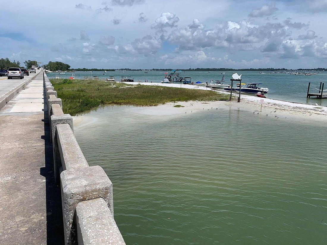
Longboat Key has plans to deepen where Canal 1A meets Sarasota Bay on the northern tip of the barrier island.
Sand from nearby beaches facing the Gulf of Mexico has filled the eastern spit of the Greer Island shoreline for years. Longboat Key town projects manager Charlie Mopps said the spit is blocking Canal 1A.
“Even since the time that I started with the town back in April of last year, it seems like it’s growing quicker,” Mopps said. “When I first got here, it wasn’t that bad, but then it just kind of accelerated the growth of the spit on the end of Greer Island, and so we have to do something.”
The town has permits in hand from both the U.S. Army Corps of Engineers and the Florida Department of Environmental Protection to dredge 1,000 cubic yards at the canal's entrance just east of the Longboat Pass bridge, according to Mopps. A typical dump truck holds about 10-14 cubic yards.
Mopps said the dredging will “increase the flow of water into Canal 1A and also to provide some boating access and whatnot back into that area.”
“Through the requests of the citizens of the north and through just observation of going out there, we’ve noticed that flushing to the lagoon of Greer Island has been getting a little bit more limited,” Mopps said. “I mean water is still flushing back there, and it’s still moving, but not as good as it could be.”
The short-term emergency project will cost tens of thousands of dollars, Mopps said. The town’s purchasing department is finalizing plans to award the work to an independent contractor. Once that happens, Mopps said the project will take a couple of weeks to accomplish.
Years ago, a fish-shaped wooden marker used to sit in the water on Greer Island near the Longboat Pass bridge just south of Coquina Beach. Now, the marker sits in the sand farther away from the water.
“It’s now at the point where it’s been expanding at like a very rapid rate,” Mopps said.
Mopps mentioned how the contractor must abide by several requirements to protect seagrass, manatees and sea turtles in the nearby area.
“It’s not like, I’ll go out there with this piece of equipment and start digging,” Mopps said. “There’s a lot of stipulations that are being imposed by the permitting agencies to make sure that it’s done right, it’s done with the most minimal impact or negative impact to the environment.”
The short-term emergency dredging at Canal 1A will precede the town’s larger plans to move between 20,000 to 30,000 cubic yards of beach-quality sand to backfill some of the north end’s most eroded gulf-facing beaches. Mopps said the larger project is still in the permitting process. Sand-saving groins are also planned on the gulf-facing beaches as part of the town's comprehensive beach management effort, designed to lock the sand in and keep it from flowing back through the pass and depositing again east of the bridge.
The price estimate for the overall project is between $750,000 to a little bit more than $1 million, which would come from the town’s beach fund. Also under discussion is a broader plan to dredge the town's miles of residential canals.
“All these projects — as you can see — what the town is trying to do is tie them together so that you get a better benefit for the money that you’re spending and the citizens are spending, but also we’re trying to be good stewards of public funds as well,” Mopps said.
Mopps said the town could do more dredging if sand accumulates again near the eastern spit of Greer Island. Even if this happens before the larger plans are completed, Mopps said the state and Army Corps’ permitting lasts for years.