- November 14, 2024
-
-
Loading

Loading

The town of Longboat Key is in the process of adopting Sarasota County’s newest base flood elevation map, which impacts flood insurance and certain building requirements on the island.
Staff with the Planning, Zoning and Building Department contemplated several new ordinances with the adoption of this new map. Those ordinances could have potentially led to a greater insurance discount for homeowners, but Town Attorney Maggie Mooney cautioned commissioners on taking any action at the moment.
Planning, Zoning and Building Department Director Allen Parsons discussed the updates with town commissioners at the Dec. 4 commission meeting, presented as the first of two public hearings on the matter.
The Federal Emergency Management Agency regularly updates base flood elevation maps as they pertain to flood insurance. Manatee County’s latest update occurred in 2021 while Sarasota County’s maps hadn’t been updated since 2016.
“It’s not anything totally new, but it is a very interesting conversation about what some of these changes are,” Town Manager Howard Tipton said at the start of the hearing.
While the main voting matter pertained to adopting the new Sarasota County flood maps as an amendment to the Town Flood Control Code, Parsons mentioned that the town participates in the National Flood Insurance Program and the Community Rating System program.
With the adoption of new flood maps, Parsons presented the opportunity to also look into potential amendments to the town’s Flood Control Ordinance and other actions that could increase the town’s status in the CRS.
“Those are things we are looking at that have the benefit long term not only on insurance discounts, but also resiliency structures,” Parsons said.
The CRS grades municipalities on floodplain management practices. Based on those points, municipalities are assigned to a “class” which then translates to flood insurance premium discounts.
Longboat Key is currently classified as a Class 6 municipality, which is reflected with a 20% discount.
In order to qualify as a Class 6 municipality, the community must fall within 2,000 and 2,499 credit points. The next level up, Class 5, requires between 2,500 and 2,999 credit points and would provide a 25% discount.
Actions to gain points are grouped by categories: Public Information, Mapping & Regulations, Flood Damage Reduction and Flood Preparedness.
During his presentation, Parsons mainly focused on the suggestion to raise the town’s freeboard requirement from 1 foot to something greater than 2 feet.
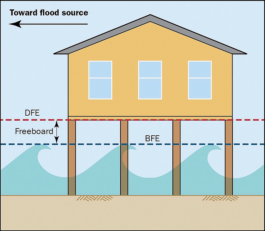
A freeboard is a safety factor for floodplain management. The addition of a freeboard accounts for unknown factors that could contribute to higher flood heights, according to FEMA.
The Florida Building Code requires at least an additional foot of freeboard elevation on top of the base flood elevation.
The previous FEMA flood maps for Sarasota County require most structures in Zone AE to be at a base flood elevation of 10 feet above sea level. Generally speaking, Zone AE corresponds to parcels east of Gulf of Mexico Drive.
But the new maps only require structures to be at a base flood elevation of 8 feet.
“So it’s a reduction of 2 feet,” Parsons said. “It’s counterintuitive, given sea level rise, which you know is not a future phenomenon, it’s a current phenomenon.”
Parsons said this reduction was attributed to advances in technology, and that previous maps may have overestimated the requirements.

Due to this reduction, Parsons suggested a potential new ordinance could be to increase the freeboard requirement in order to maintain a “status quo.”
For a given structure, the design flood elevation represents the elevation from sea level to the bottom of the first habitable floor. The design flood elevation is a combination of the required base flood elevation and freeboard.
Higher Regulatory Standards is a subsection under the Mapping & Regulations credit category. The section includes freeboard requirements, which can earn an average of 272 points.
Another suggestion that Parson’s staff outlined was to raise the minimum seawall height to 4.5 feet for all new or rebuilt seawalls. This was already a recommendation for the Sea Level Rise & Resiliency Comprehensive Adaptation Plan that staff is also working on.
With the potential for more credit points on the table, Parsons also pointed out that any actions taken must be carefully considered.
“Any changes to land development codes that are considered more burdensome or restrictive, there’s a flat out moratorium from Manatee County southward,” Parsons said. “So if we were to have any regulatory changes, they would have to be structured in such a way that they wouldn’t be considered more burdensome.”
This is because of Senate Bill 250, which prohibits counties and municipalities within 100 miles from Hurricane Ian or Idalia’s landfall from adopting those more burdensome restrictions. The moratorium is set to last until October 2024, unless the state legislature extends it.
The prohibition of adopting more restrictive codes puts the town in a tight position when considering these new potential ordinances to get more credit points.
Mayor Ken Schneier questioned whether the freeboard requirement would be allowable because it would “eliminate the negative,” but Town Attorney Maggie Mooney said it would not be possible to consider the ordinance.
“Now, the reality is, is that I don’t know that the legislature contemplated the consequences like this, preventing communities from creating more flood control and flood prevention by adopting that regulation,” Mooney said.
Mooney also said that Pinellas County was originally a part of Senate Bill 250, but, after showing there wasn’t significant impact up there, was not included in the latest iteration of the bill.
While Mooney suggested that a point about the unintended consequences should be made to delegation members, Tipton doubted the possibility of Longboat Key receiving the same exemption.
Tipton said his assumption is based on the town’s proximity to North Port and Venice, which had significant impacts from the storms.
“We're gonna have to get creative over the next couple of years rather than just sort of throwing up our hands and saying, you know, nothing we can do,” Parsons said.
One potential work-around that was suggested was to raise the maximum seawall height allowance, while continuing to not have a minimum. This would allow landowners to build higher seawalls to prevent flooding, but would not be restrictive.
After lengthy discussion about the possibilities, commissioners directed Parsons and his staff to look into the freeboard, seawall and other optional ordinances to see if there were ways for them to be “creatively” adopted.
The main voting matter at hand, though, was the adoption of the new FEMA flood maps. Voting to not adopt the maps would have potentially kicked the town out of the CRS program, or at least down to the lowest class.
But the maps were approved 7-0 to move to a second hearing on Jan. 8, 2024.