- May 1, 2025
-
-
Loading

Loading
Though not all commissioners saw a clear reason for it, the town passed an ordinance to allow for 2 feet of additional freeboard in low-lying areas.
On June 3, Planning, Zoning and Building Department Director Allen Parsons presented the ordinance to commissioners. It was an extension of an ordinance passed on April 1, both of which allowed for optional freeboard to be added to the design flood elevation of new construction on the island.
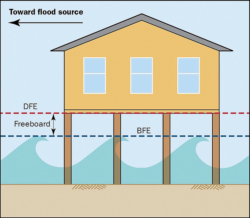
A building’s design flood elevation (DFE) equals the base flood elevation (BFE) plus the freeboard. The DFE is the height to the bottom of the lowest habitable floor.

The Florida Building Code requires 1 foot of freeboard. Freeboard is a flooding safety feature that is added to the BFE.
The BFE is the estimated level of surface water expected during a 100-year base flood event.
Previously, commissioners approved an ordinance on April 1 to allow for an optional 2 feet of freeboard islandwide, which brings the total allowance to 3 feet.
The ordinance was sparked in January when Parsons presented to the commission new Sarasota County flood control maps developed by the Federal Emergency Management Agency. These maps suggested a reduction in base flood elevation recommendations by 2 feet, generally islandwide.
In 2021, FEMA also updated Manatee County’s flood control maps with a similar decrease in base flood elevation.
Parsons said that these reductions in BFE were possibly the result of better technology that can more accurately measure and predict flood elevations, according to FEMA.
“Surprisingly enough, I would say that the reduction of 2 feet is something that FEMA has indicated that maybe the prior maps were overestimating what the flood elevation was,” Parsons said.
After January, the Planning & Zoning Board worked on an ordinance to allow the optional freeboard to maintain the status quo after FEMA reduced the base flood elevation requirements.

The idea to adopt an ordinance for the extra 2 feet — or 5 feet total — in low-lying areas was brought up at a March 4 meeting. Still, commissioners wanted more research by staff before proceeding with the ordinance.
Commissioners unanimously approved the first freeboard ordinance — 2 feet of additional freeboard, or 3 feet total — and awaited staff’s research on the further addition, which came at the June 3 meeting.
At the commission’s June 3 regular meeting, Parsons presented the ordinance as it was outlined by the Planning & Zoning Board.
The language included that the option to include 2 more feet of freeboard — 5 feet total — would only apply to low-lying areas “at or below 3.5 feet North American Vertical Datum (NAVD), as determined by the Planning and Zoning Official based on a topographical survey…”
The NAVD is a measurement from a surface of zero elevation — or sea level — from which the heights of other points are calculated.
Parsons said the town has recognized that properties flood frequently during high tides and rain events, and impacts come even without catastrophic events.
“So what this is providing for is low-lying properties to be able to choose to elevate without bringing in fill,” Parsons said.
Vice Mayor Mike Haycock spoke in opposition to the additional freeboard allowance. He felt like this wasn’t solving a current problem, and worried this would allow for taller houses.
“What I'm concerned about is that we don't have a problem that we're trying to solve, we’re going to put a code in that’s kind of complicated and it's going to result in taller houses. And we do know that our public doesn't like taller houses next to the small houses,” Haycock said.
Commissioner-At-Large BJ Bishop’s rebuttal supported the new freeboard ordinance, and said that the ordinance would allow for more resilient new construction through the added height.
“Part of our job is to look at what is the long-term impact on this community being viable and, right now, this community in 50 years, if we stay at grade the way we are now, there will be a community here,” Bishop said.
Town Manager Howard Tipton assured commissioners that this ordinance would not allow the additional freeboard islandwide.
“And I think it's clear that this is intended for a very narrow subset for the island,” Tipton said during the discussion.
Property owners would have to prove to the building official that the lot qualifies through topographic surveys.
During the public comment section, Planning & Zoning Board member S. Jay Plager spoke to the commission about how the Planning & Zoning Board felt under pressure to deliver an ordinance to the commission as quickly as possible and agreed that some of the language may be confusing.
Plager also agreed with Haycock’s point that this ordinance does not address properties who currently experience flooding, and will only assist those constructing new houses.
“Nothing in this ordinance is going to help them directly,” Plager said about current residents experiencing flooding. “They need help but not through this ordinance.”
The commissioners in favor of the ordinance agreed that the 3.5 feet should be determined by topographical surveys, and the specific language of the ordinance could be modified later as needed.
The vote to adopt the ordinance was 4-2, with Haycock and District 1 Commissioner Gary Coffin voting against the ordinance.