- March 12, 2025
-
-
Loading

Loading

The future of the Longboat Pass Bridge will soon be up for discussion.
On March 14, the Florida Department of Transportation will hold a public workshop to discuss potential alternatives for the Longboat Pass Bridge. The meeting will be held from 5-7 p.m. at Christ Church.
The FDOT is currently in the Planning, Development & Environment (PD&E) Study phase, and the department is now seeking public input on the four different alternative solutions that have been drawn up.
The entire scope of the $2,125,000 study spans 0.75 miles of State Road 789 from North Shore Road on Longboat Key to the Coquina Park Entrance. The FDOT paid for the study, which began in February 2020.
After the alternatives public workshop, a public hearing will be held sometime in early 2025, according to the project’s website. By early 2026, the FDOT is aiming to get study approval and location design concept approval.
On the project website, the FDOT lists the project goals as: address the structural integrity and operational deficiencies of the bridge, improve bicycle and pedestrian facilities, and improve emergency evacuation and response times.
As of now, there are four alternatives that the FDOT is proposing for the Longboat Pass Bridge. The alternatives were derived from their PD&E study.
First is a no-build option. This would mean that the existing bridge structure would remain in place.
The bridge as it stands now is 17 feet above the mean high-water line, and has a width of 50 feet between fenders. It was built in 1957, then renovated in 2005 and 2020, according to the FDOT website.
It is now classified as “functionally obsolete" by the FDOT due to the age and design of the shoulders and traffic barriers.
An “Alternatives Evaluation Matrix” released by the FDOT — which will also be available at the workshop — estimates that the existing bridge would have a remaining lifespan of about 10 years.
Marine traffic often requires the drawbridge to open and disrupt traffic. The matrix estimated that the bridge opens about 100-300 times a month.

Since there would be no changes to move forward with a no-build option, there would be no cost, but the matrix includes a footnote saying that the no-build option would include “increasingly costly maintenance and repair projects causing continued disruption to traffic.”
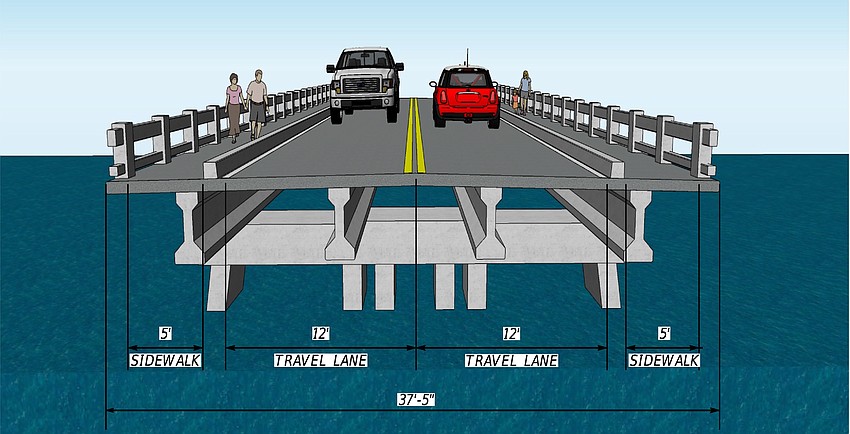
The current bridge has two 12-foot travel lanes with a 5-foot sidewalk on each side. The sidewalks and travel lanes are separated by 9 inches of concrete.
Build alternative number one would be a low-level bascule bridge with a vertical height of 23 feet above the mean high water line.
A bascule bridge is a type of moveable bridge (i.e. drawbridge) designed to handle heavy loads.
With an increase in height, this alternative is estimated to decrease the amount of bridge openings by about 4%.
Design costs for the low-level bridge would be about $7.5 million, with a total project cost of about $133.2 million.
A mid-level bascule bridge is the second build alternative. This bridge would be 36 feet above the mean high water level.
This would be expected to reduce bridge openings by about 35%.
The design would cost around $7.5 million with a total project cost coming in at $133.9 million.
Lastly, there is an alternative to build a high-level fixed bridge with no drawbridge. This bridge would be 78 feet in height from the high water line and eliminate bridge openings altogether.
This option is the only one that would impact the roadway enough so that the entrance to Coquina Beach would have to be shifted about 500 feet north.
Design costs would be around $4.5 million for this bridge and the project as a whole is estimated to cost around $93.3 million.
All three build options are estimated to have a lifespan of 75 years. They would all also have a low potential impact to threatened and endangered species, impact 0.10 acres of wetlands and impact 0.22 acres of seagrasses.
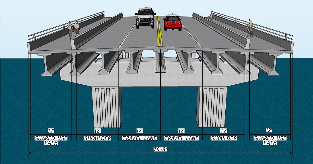
The three build options are also all the same width — 90 feet between fenders — with the same lane configuration.
Proposed in the preliminary design are two 12-foot travel lanes, a 12-foot shoulder on each side followed by a 12-foot shared use path on each side. Adding a shoulder and increasing the width of the concrete separator would address issues of bicyclist and pedestrian safety.
The information included in the matrix is preliminary and subject to change.